Blogs > Cliopatria > Olaus Magnus' Carta Marina

Oct 12, 2008

Olaus Magnus' Carta Marina


One of the oldest known maps of the Scandinavian countries and the region around the Baltic Sea is the 1539 Carta Marina (Map of the Sea), a magnificent chart created by Olaus Magnus, an exiled Swedish priest and cartographer living in Italy at the time. The map is filled to every corner with rich, painstakingly detailed drawings of the fantastical beasties that active sailor imaginations populated the seas with: winged fish, sea-dragons, hirsute many-eyed trout, galleon-sized snakes and other monsters worthy of even Hieronymus Bosch.


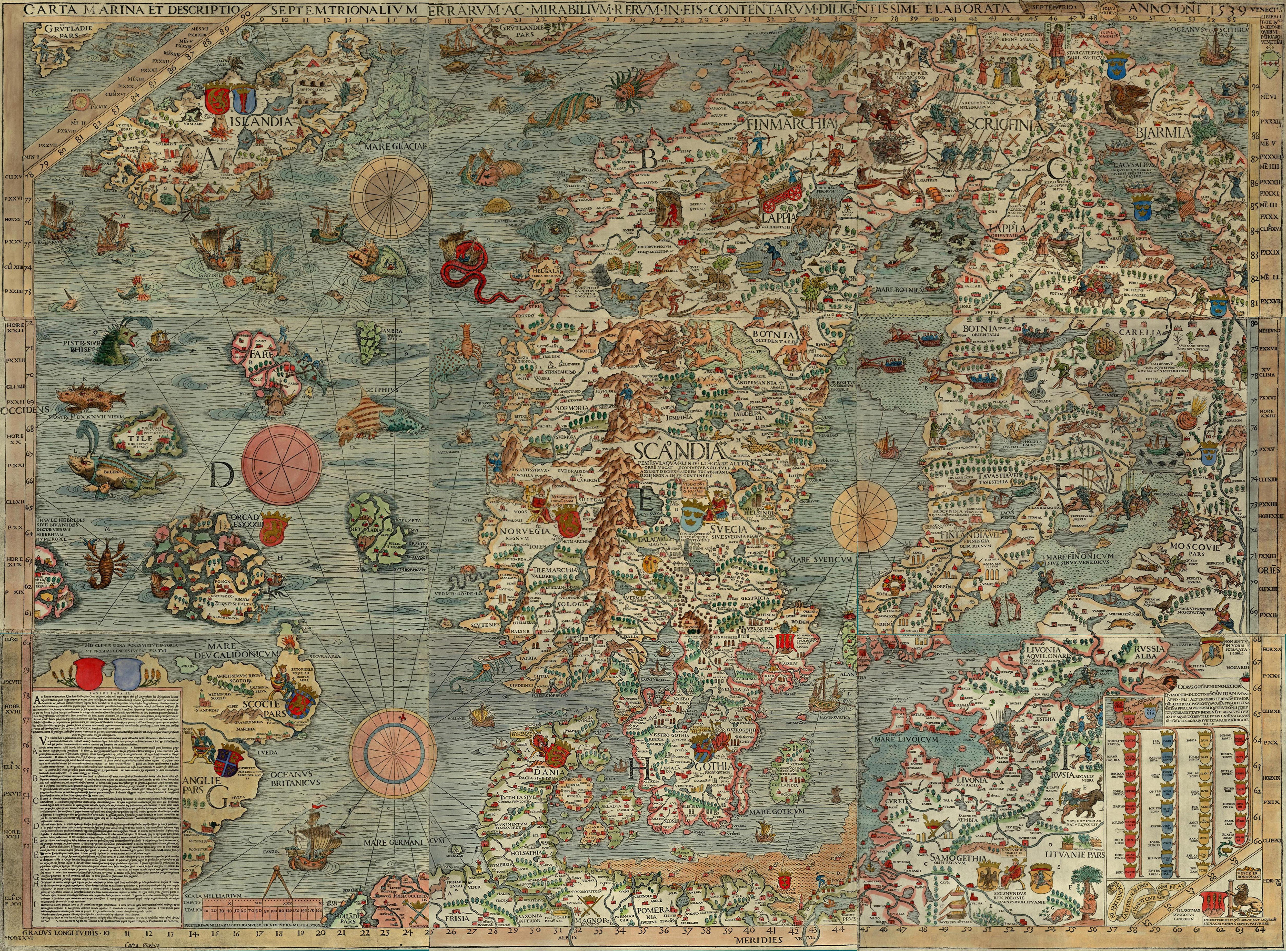
The map has long been seen as gorgeously ornate, but technically crude, lacking in the sophistication that characterizes modern cartography. However, researchers four years ago found that the fanciful swirls and whorls drawn on the map of the seas east of Iceland are potentially much more than just bored artistic license: they correspond with astounding accuracy to thermal satellite imagery of the Iceland-Faroes Front, where the Gulf Stream meets the colder Arctic waters, creating huge eddies - bodies of water up to a hundred kilometers in diameter that spiral lazily as the waters of different temperatures interact.

What I found most interesting was that though the map was reissued in 1572, the new map meticulously reproduced the original Carta Marina down to the last detail except for those swirls and whorls. Thirty years on, it seems that the mapmakers had simply forgotten or not understood the function of the whorls in conveying useful navigational information. These symbols, once laden with content and meaning, faded into mere aesthetics - the fate, I thought then, of careless religious gesture, like prayers uttered without faith, or traditions celebrated without understanding or remembrance. How much of the past is like that to us? - dead or unrecoverable contexts, lost meanings, inexplicable deeds... Well, at least in the absence of meaning, the Carta Marina is still beautiful (best viewed large, scrolling reverentially). One could hardly say that for some history, especially the parts that seem the most devoid of meaning of all.


comments powered by Disqus

More Comments:


Les Baitzer - 10/13/2008

You're welcome. And, it occured to me that your accidental error has created a splendid trivia question for word-game fanatics.

"Name two Countries whose names can be changed to another country by changing only one letter?"

(Perhaps there are more than two ...)


Rachel Leow - 10/12/2008

Thanks, I did mean that, & it is now changed :)

I suppose the enduring strategic importance of the Faroe Gap, which you make so clear, would help account for the exhaustive detail of Magnus' map in charting that particular region. There's still some dispute, you see, regarding these swirls, and whether or not their correspondence is not really just accidental. Magnus appears to have written an entire book on the History of the Nordic Peoples in 1555, in which he refers in great detail to this map right down to the miniature ice skaters on one of the lakes, but never mentions the swirls at all, let alone explain their purpose. It's possible that the swirls articulated some very common knowledge among sailors, so common that it needed no further explication. But we'll probably never know...


Rachel Leow - 10/12/2008

Tell me a little more about substantives and accidentals - I am ignorant of such distinctions & so do not know how to extrapolate to maps. If I accidentally change the sentence "She is fit" to "She is fat", is that both accidental and substantive?


Les Baitzer - 10/12/2008

I believe that in your second paragraph, 5th line, you meant " ... the seas east of Iceland ..."

What is also interesting about that area is that, although the tricky seas are not a significant challenge to modern shipping, this ancient and relatively narrow route (now commonly referred to as the "Faroe Gap"), remains the principle path for Russian (and formerly Soviet) shipping transiting north and south. The Faroe Gap also exists in international air routes above.

Since both ships and aircraft are virtually “forced” to transit in this narrow area, it has offered an excellent location for the West to observe and monitor Soviet and Russian shipping and aircraft for over fifty years.


Timothy Carmody - 10/12/2008

The immediate analogy that comes to mind is the distinction between substantives and accidentals in textual editing, with the now-contested assumption that "accidental" changes in spelling, punctuation, etc., don't alter the meaning of a text.

What counts as an accidental and what counts as a substantive in the editing of a map? The spelling of a name? The paratext? How countries are colored, if at all? Or is it only coasts and borders, the locations of cities?