"Cities are the Living Embodiments of Past Decisions"
4-22-13

Robin Lindley (robinlindley@gmail.com) is a Seattle writer and features editor for the History News Network. His writing—often interviews of writers, scholars and artists—also has appeared in Crosscut, Writer’s Chronicle, Real Change, The Inlander, NW Lawyer, and other publications. He audited Dr. O’Mara’s urban history course—but excused himself from the SLU micro-history project.
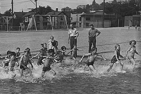
Children in wading pool at Cascade Playground, Seattle, 1939. All photos credit Seattle Museum of History and Industry.
Stories about place are makeshift things.
They are composed with the world’s debris.
--Michel de Certeau
In most undergraduate history classes, students are required to take tests and write a paper or two.
But University of Washington history professor Dr. Margaret O’Mara wanted to tap into her students’ curiosity and their relationship with the web and technology for her history of U.S. Cities course last winter.
To bring urban history to life for her students and encourage them to explore and see their world in new ways, Dr. O’Mara created an innovative project that focused on Seattle’s dynamic South Lake Union neighborhood, now an area of high-tech businesses, medical clinics, trendy eateries, and pricey real estate.
Dr. O’Mara assigned each student a city block to study in depth, and the work required -- among other things -- close observation, questioning, reports of findings, photography, an audio tour of the block, peer review, studying primary sources such as public documents, news articles, photographs and maps, and then creating an online portfolio of this micro-history.
As Dr. O’Mara notes, many think of South Lake Union before the high-tech boom of the past decade as a place to drive through to get somewhere else. But her students discovered a many-layered history with Duwamish and other Native settlements; pioneer David Denny’s 1853 land claim; a railroad to transport coal; cheap housing for immigrant workers; sawmills and other light industry; Bill Boeing’s first airplane shop; a Ford Model T plant; marine enterprises; auto dealerships, laundries, schools, stores, churches, houses, clinics; an interstate freeway; traffic woes; repeated manipulation of the shoreline and the land; countless lives of the people who worked and lived and sometimes died there; and more.
Dr. O’Mara is a specialist in American urban and political history at the University of Washington. She also has taught at Stanford and the University of Pennsylvania, where she earned her doctorate. Her acclaimed book Cities of Knowledge: Cold War Science and the Search for the Next Silicon Valley (Princeton, 2005), probed the relationship between metropolitan development, higher education, and the Cold War state in shaping the geography of the high-tech economy. Dr. O’Mara’s current research pursues these themes on a transnational scale, considering economic globalization and urban change in the U.S. and around the world since 1940. She also is currently writing a book that explores the high tech landscape from the 1970s to the present, including the evolution of South Lake Union.
Dr. O’Mara recently talked about her work in urban history and the South Lake Union project at her office in Smith Hall on the main UW campus.
Robin Lindley: How did the South Lake Union project fit into your course on urban history of the United States?
 Dr. Margaret O’Mara: I enjoy teaching urban history because when we ground history in physical place and link the changes in built environment and human environment and natural environment to economic, political, social and cultural changes, it makes history much more tangible and more real.
Whenever I teach urban history, I like to have a story element about the place my students are living. When I was in Philadelphia, I’d talk about Philadelphia. In the Bay Area at Stanford it was funny because they didn’t think of Palo Alto as urban, but of course it’s the ultimate post-industrial city in Silicon Valley.
Integrating examples from places that are very familiar, very ordinary, where people are moving every single day, makes the history much more real and makes students look at their surroundings with more awareness so urban history becomes this vehicle for history to come alive for students.
The South Lake Union project was inspired by that desire to get students to look critically at something familiar more closely and ask questions about it. History is all about challenging assumptions about why things got the way they are.
What did the project involve?
Each student did an intensive micro-history on a one-block area, which is small enough to get your hands around in ten weeks.
I think South Lake Union is American history in microcosm. Almost everything I talked about in class (on the evolution of cities), you could see played out in South Lake Union, such as the urban freeway system -- and not only the one that got built, I-5, but ones that didn’t get built.
Urban history is intellectual history as well with ideas about planning and what cities could and should be that are so reflective of society.
Future historians will look at the world of 2013 and the conversation on urban planning, sustainability, green building, and all of the things that we’re hot on right now, and that’s a window into our soul. Instead of asking what we wanted to be and what was done wrong, they’ll also be [asking] were we successful in this or not and how did we measure success? Was our benchmark of success progress? Was this an advance? Was it innovative, and if it was innovative was it a good innovation or one we look at cockeyed?
The project must expose the hidden history of South Lake Union and forgotten people who resided and worked there before it became an expensive high-tech ghetto.
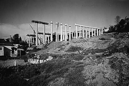
Freeway construction near the intersection of Lakeview Boulevard and Eastlake Avenue, Seattle, 1961.
Really South Lake Union and all of the neighborhoods around it are vivid examples of how environmental history and social, cultural and political history intersect. Human-driven [decisions] graphically altered the landscape from turning marsh into landfill and altering the coastline to the Denny Regrade to the smaller regrade to the building of I-5.
These are both the causes and the reflections of broader economic, social and political history. The current discourse on South Lake Union is the imaginary ultimate green, high-tech neighborhood. There [supposedly] wasn’t much there there before, but my student project shows that it was full: full of people, activity, perhaps things that were marginal. It was the classic light-industrial zone in transition [with] Laundromats, garages, homes. There was ethnic and racial diversity.
The area shows the consequences of planning even when things don’t get built. The freeway was a primary case in point. All around Mercer, development was frozen in amber because the freeway was going to come. That helps us understand why there was land there for [Microsoft billionaire] Paul Allen to buy.
Here’s an example of a neighborhood that was affected by what was built and what was supposed to be built, but didn’t get built. That possibility for so long was the reason development halted in a few blocks. A few students said, “Nothing happened on my block between year X and year Y.” Then we talked about the freeways. And even blocks that were not in the path of the freeway were near enough that property owners sat on it waiting for property values to go up, or no one would buy it because it was going to be so close to a freeway.
It’s a way for all of us to see the very tangible aspects of policy decisions, of ideas and how they play out in a place. In urban history, it’s often easy to look at built environments and think that great, unseen forces crafted them. But if you stop and really think about it, of course it was human beings. So who built it? Why did they build it? Why were they empowered to build it? Who walked out? How does it reflect the politics, the power structure, the culture of the time: economically, intellectually, socially.
It [South Lake Union] was seen as a place to get through and some of my students picked up on that insightfully. Here’s neighborhood in the heart of the city -- and it can be the heart of the city, or a place you go to get somewhere else. It was a place in the middle between downtown, Capitol Hill and the U-District.
And there was a great deal of topographic manipulation designed to increase real estate values in that area, and that didn’t happen. The Denny Regrade wasn’t built upon for a long time, hence giving airspace for the current wave of development.
With your project, students looked at the past from many angles by photographing their blocks, creating an online portfolio of their writing and digital illustrations, and using primary resources such as maps, news articles, and public documents to build their narrative.
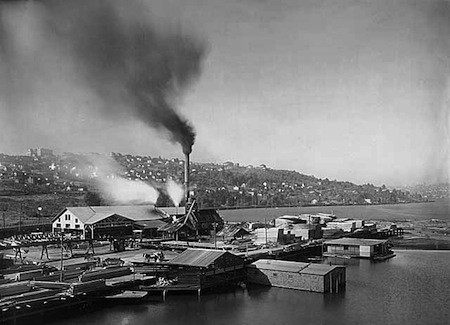
Brace and Hergert Mill, Seattle, ca1910.
I had very specific learning goals. I was dissatisfied with the five-page history paper [assignment]. That modality wasn’t sparking intellectual excitement, and the students are living their lives online.
I told them the first day of class that this is a grand experiment. It was very important to [say] that we’re all going on this adventure together and I want your feedback. I wanted to empower them to think critically about different types of writing and how they write.
And there’s a proliferation of [online] information that is poorly sourced so I wanted to make them hyper-conscious of sources and citations.
If nothing else, I hope they gained an appreciation for the different types of sources and how to properly attribute authorship and identify when a photograph was taken. And, by doing that, you have interpretive information: this was taken by a reporter from the Seattle Times. Why was he sent out? What happened? It looks like a wagon accident. What is focused on and what is not? Are there other shots that were just throwaways? What does that tell us? Who are the people walking down the street? Do they look working class or middle class? There are so many things you can read.
A map is not an unbiased document. It’s not a factual document. Who created it? For whom was it created? What is emphasized? What is included? What is left out? What does a map tell you about what’s going on? It has factual data, too.
So it becomes data for the beginning of the treasure hunt.
We all live on the Internet and it challenges our capacity for long-form reading and it presents us with a visual array of things that’s turning all of us into more visually oriented learners.
I want students to look at historic photographs [and] maps as texts that are just as rich in historical data points as one of Jefferson’s letters on the state of Virginia.
And I wanted them to be excited and for them to think of history as detective work. They have to use evidence to build an argument. It’s all these basic things that we try to convey on historical writing: evidence-based argumentation and critical thinking and analysis.
What inspired your project?
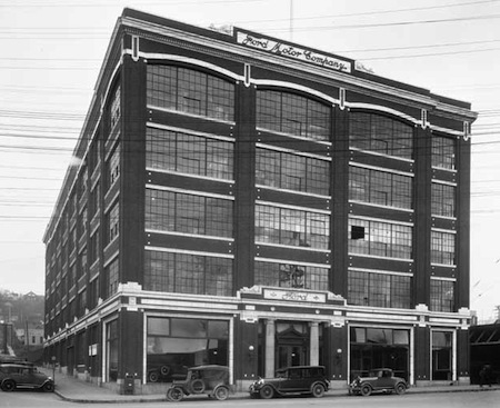
Ford Motor Company assembly plant, ca. 1928.
This block-by-block micro-history project was inspired by a mentor in graduate school, Anne Spirn, a landscape architect and urban planner who now teaches at MIT. When I was working with her at Penn, she gave each student a six-block area in Philadelphia. She also was very mindful in her writing and her teaching of nature, and she asked us to look up, look down, and look around at the traces of nature in the city. We have constructed nature, we have annihilated nature, and just because you build a city doesn’t mean that nature doesn’t matter.
Like my project, she [required] a series of short reports: one was a close reading of the site; one was an environmental history of the site; and so on. I freely admit [her inspiration]. Mark Twain has a wonderful quote about how every good idea is one that other people thought of, but the last guy gets the credit. But that’s the way it works.
The other reason that urban history is so exciting and important is that it’s inherently multidisciplinary. Those of us who are urbanists are working across a lot of disciplines. Someone like Anne is teaching at the school of planning at MIT. But we’re asking similar questions in slightly different ways with different sources and methods. But when you put those together, it becomes something greater than the sum of its parts.
It’s rare that an urban historian isn’t actively working with people from other disciplines. I don’t think we’re alone in that among historians, but the nature of the subject is one thing that makes it exciting and challenging. It forces us to get out of writing and speaking a language that only other historians understand and translate what we say and do to a wider audience from other backgrounds.
Cities are the living embodiments of past decisions, and we have to reckon with those past decisions to properly understand where we sit right now, and to properly plan for the future. We cannot operate in a vacuum and say we’re dissatisfied with the way things work and change it without really reckoning with how we got to this unsatisfactory place.
You also had students create an audio tour -- another challenging aspect of the project.
The audio tour was an idea of my friend Phil Ethington at USC, and he’s one of the people behind the Hypercities Project. It was so great to hear their voices, and some of them were gung ho and became full-on tour guides: “Welcome. This is my block.” I don’t think any of them will look at South Lake Union the same again. They’re going to have inside information, which is exciting because it’s a dynamic neighborhood that’s a focus of attention.
I love the idea again of empowering students to do serious historical research and to have something that lives on past the quarter where the student can say, “I helped build that, and I was in a history class, and I’m part of this app.”
What surprising information have the projects revealed?
I don’t know if I’m able to say that yet because this is an ongoing project and I have a next phase where I hope that question will be answered. A graduate student [will create] a homepage with a map-based interface, so you come to the South Lake Union Stories homepage map of the neighborhood, and you click on a block and go to the report on that block.
The other bigger piece that this feeds into is an emerging research collaborative that I’m embarking upon with a number of UW colleagues, most notably my collaborator Thaisa Way, a historian in the Department of Landscape Architecture. She is also interested in Lake Union and [her] students also [studied the] history of the lake. Thaisa and I want to bring the collective work of our students together in one shared world where people can learn not only about the environmental, social and economic history of the South Lake Union neighborhood, but also about the lake and its north end.
Did your students express misgivings about the rapid growth of South Lake Union?
My students had a debate in sections on height restrictions, and the groups for taller buildings had a field day, and the ones [opposed] to raising building heights felt they were on the wrong side. There was a social justice concern, but to have a lively urban environment, you’ll have to raise building heights. Part of that reflected that they noticed if one block was lively because of mix of uses and another one was [dead]. So my students can come into the conversation as proponents of density.
You’ve mentioned that world cities consume about 80 percent of all energy but only 50 percent of people live in cities. Are cities sustainable now? With new technology, can’t people spread out and work away from cities?
Even when spread out, we still need to connect. In the last 30 years, as technology became more ubiquitous, we could all live conceivably in a cabin in Montana if we had a broadband connection. But could you do all the work you need to do without any human contact?
There’s a reason that real estate prices in places like Seattle and Silicon Valley and all of the hot high-tech areas spiral up because people want to be there. Fifteen years ago people predicted that we didn’t need to be camped together -- we could spread out. But the broadband age has proved that we don’t. The problem is that we’re in middle ground where we live in low density, suboptimal ways and we get in cars to connect with one another, so we have the worst of both worlds.
There’s a robust debate, and I’m on the side of those who think that cities are more green. Manhattan is one of the greenest places in the United States because fewer residents drive. Cities are part of the climate change problem, but they are also a critical part of the solution.
Is there anything you’d like to add about the South Lake Union project?
It’s like every research project. The coda has not yet been written. One of the best marks of success is to engage students and get them to think differently. I feel it did that in a way that a five-page paper couldn’t. It empowered them, I hope, to think about their online presence and the relationship with the online work and their work in the classroom in a different way. And I hope they’ll always continue to explore and think more mindfully about the urban environment that they live in.